
Project Resources
About the
Project
The Rockland Riverway Trail project will transform and enhance the existing major roadways, pedestrian, and non-motorized trails along the eastern side of connect communities across Rockland County into a shared-use pedestrian and cycling network. This proposal does not include construction of any new trails or roadways. The Trail will cross through 10 different municipalities in the County and runs a total of approximately 21 linear miles.




Scoping Documents
The Scoping Period, which begins May 6 and ends June 1, is the first step in the environmental review process for the project. During the Scoping Period, Rockland County will collect verbal and written comments from the public that will contribute to the development of the Environmental Impact Statement (EIS). The EIS is a comprehensive document that evaluates a project’s potential environmental, social, and economic impacts to comply with State review.
On May 6, Rockland County published a Draft Scoping Document to start the scoping process.
The document includes information about:
The project’s purpose and needs
Project elements that Rockland County will consider during the project timeline
Alternatives that will be studied in the EIS
Additional documents below:
Public input is an important part of the scoping process. All comments received verbally or in writing during the Scoping Period will be addressed in the final scoping document.
Written comments were accepted through June 1. You may send your comments to The ARPA Department, 50 Sanatorium Road, Building A, 8th Floor, Pomona, New York 10970, or ARPA@co.rockland.ny.us
Draft Generic Environmental Impact Statement (DGEIS)
On July 29, Rockland County published a DGEIS hearing notice, which starts a public comment period where the public can review and comment on the DGEIS.
This Comment Period, which began July 29 and ended August 24, is the next step in the environmental review process for the project. During this public comment period, Rockland County will collect verbal and written comments from the public that will contribute to the development of the Draft General Environmental Impact Statement (DGEIS). The DGEIS is a comprehensive document that evaluates a project’s long-term potential environmental, social, and economic impacts to comply with federal, state, or local review.
You may comment on the DGEIS by:
Attending the DGEIS Public Hearing on August 13, 2026 and providing a verbal comment up to 3 minutes long
Sending a letter to The ARPA Department, 50 Sanatorium Road, Building A, 8th Floor, Pomona, New York 10970
Sending an email to ARPA@co.rockland.ny.us
-
Appendix A.1: Full Environmental Assessment Form, Part 2
Appendix A.2: Final Scope for the Draft Generic Environmental Impact
-
Appendix B.1: 80% Design – Segment 1
Appendix B.2: 80% Design – Segment 2
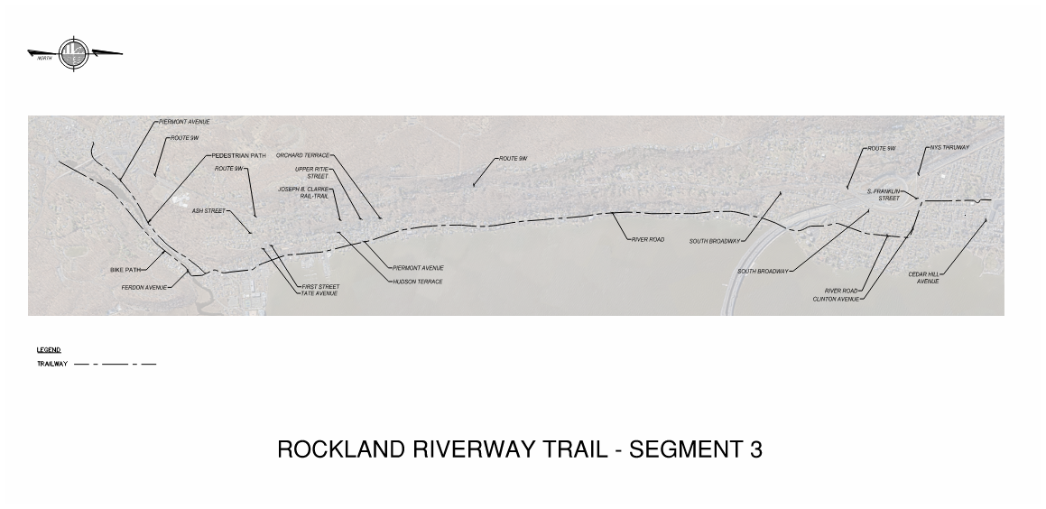
Appendix B.3: 80% Design – Segment 3
Appendix B.4: 80% Design – Segment 4
Appendix B.5: 80% Design – Segment 5
Appendix B.6: 80% Design – Segment 6
Appendix B.7: 80% Design – Segment 7
Appendix B.8: 80% Design – Segment 8
Appendix B.9: 80% Design – Segment 9
Appendix B.10: 80% Design – Segment 10
Appendix B.11: 80% Design – Segment 11
-
-
Appendix D.1: Segment 1 Disturbance Plan
Appendix D.2: Segment 2 Disturbance Plan
Appendix D.3: Segment 3 Disturbance Plan
Appendix D.4: Segment 4 Disturbance Plan
Appendix D.5: Segment 6 Disturbance Plan
Appendix D.6: Segment 7 Disturbance Plan
Appendix D.7: Segment 8 Disturbance Plan
Appendix D.8: Segment 9 Disturbance Plan
Appendix D.9: Segment 10 Disturbance Plan
Appendix D.10: Segment 11 Disturbance Plan
-
-
-
-
-
Read the DGEIS Appendices
Final Generic Environmental Impact Statement (FGEIS)
Rockland County has completed a Final General Environmental Impact Statement (FGEIS). The FGEIS is a comprehensive document that evaluates a project’s long-term potential environmental, social, and economic impacts to comply with federal, state, or local review.
-
Appendix A.1: 100% Design Segment 1 (Route 9W through Route 9W/Highland Avenue)
Appendix A.2: 100% Design Segment 2 (Route 9W/Highland Avenue through Joseph B. Clarke Rail Trail)
Appendix A.3: 100% Design Segment 3 (Joseph B. Clarke Rail Trail through Cedar Hill Avenue)
Appendix A.4: 100% Design Segment 4 (Cedar Hill Avenue through Larchdale Avenue/North Broadway)
Appendix A.5: 100% Design Segment 5 (Larchdale Avenue/North Broadway through Haverstraw Beach State Park Trailhead)
Appendix A.6: 100% Design Segment 6 (Haverstraw Beach State Park Trailhead through Samsondale Avenue/Bowline Plant Road)
Appendix A.7: 100% Design Segment 7 (Samsondale Avenue/Bowline Plant Road through Tomkins Avenue/County Road 110/Farley Drive)
Appendix A.8: 100% Design Segment 8 (Tomkins Avenue/County Road 110/Farley Drive through Park Road and Route 202/Route 9W)
Appendix A.9: 100% Design Segment 9 (Route 202/Route 9W and Park Road through Route 202/Route 9W and River Road)
Appendix A.10: 100% Design Segment 10 (Route 202/Route 9W and River Road through Jones Point Bike Path West Trailhead)
Appendix A.11: 100% Design Segment 11 (Route 202/Route 9W and Jones Point Bike Path West Trailhead through Orange County)
Appendix A.12: Technical Specifications
Appendix A.13: Updated Stormwater Pollution Prevention Plan
-
Appendix B.1: Public Hearing Transcript
Appendix B.2: Written Comments
-
Appendix C.1: Phase 1A Archaeological Investigation
Read the FGEIS Appendices
Public Engagement
August 2026 Community Meetings
Draft Generic Environmental Impact Statement Hearing
September 2026 Virtual Public Information Session
Contact
For questions or feedback on the Rockland Riverway Trail or the project, please contact rocklandriverwayevents@gmail.com.